- Details
The Storage Manager has started a review of the Storage Management Rules for the for the Wimmera-Glenelg headworks system. The rules form the basis for how the system is operated day-to-day to support water security for the region.
The review aims to improve and refine the current Storage Management Rules and operation of the Wimmera-Glenelg system, taking into consideration any new data, information and operational experience, to better meet the needs of entitlement holders and improve efficiency. This could include both the storage and delivery of water.
Headworks refers to 10 Grampians reservoirs, the channels and waterways which connect them, as well as the infrastructure and equipment that controls water flow.
The Department for Environment, Land, Water & Planning (DELWP) and entitlement holders can trigger a review, which is required periodically. The current review was initiated in October 2018.
The review focuses on the daily management of the headworks system to optimise water security in the Wimmera-Glenelg system. It is not about changing water entitlements or water allocations or how water is shared within those entitlements.
The review is expected to be completed by early 2021.
![]() Fact Sheet - Wimmera-Glenelg Headworks Operations Review
Fact Sheet - Wimmera-Glenelg Headworks Operations Review
- Details
Join us for the next Customer and Stakeholder Workshop on Friday 12 September 2025, 9.30am at the Horsham Town Hall.
Topics Include
- Water Resource Position and Outlook
- Supplementing Horsham and Natimuk Urban Water Supply
- Customer Survey Results
- Investment Strategy
- Details
Congratulations to our recent winners who each received a $100 credit on their water bill!
Tapping In Edition 4, 2024/25
Question: What percentage of electricity will be offset by the Nhill Renewable Energy Facility?
Answer: 70%
Winners:
- SG< Drummond, Horsham
- K McLeod, Alfredton
- BC & MI Hogan, Birchip
- N & P Keyte, Haven
Thank you to all who provided feedback during our recent Customer Survey.
We congratulate our five winners who were randomly selected to receive a $200 credit on their water bill in July 2025!
- Colin F, Horsham
- Lemoir K, Natimuk
- Peter F, Hopetoun
- Aileen S, Natimuk
- Tracy E, St Arnaud
Terms and Conditions
|
Entry Requirements and Restrictions: 1. Answer our competition question to go into the draw to win one of four $100 credits. Entries can be:
|
General Information:
|
- Details
GWMWater is upgrading water meters with 'remote meters' across urban areas in our service area following a successful roll-out for rural pipeline customers.
Urban Remote Meters (URM)
A remote meter measures, in real time, the amount of water a customer uses.
The digital device is different to a standard meter because it includes a low frequency radio transmitter that securely sends water use data to GWMWater for billing and operational purposes.
The water usage information will be available to customers via the GWMWater Customer Portal, making it easy for customers to monitor their water use.
For more information:
![]() Fact Sheet - Urban Remote Meters - June 2019 (5.2MB, 2 pages)
Fact Sheet - Urban Remote Meters - June 2019 (5.2MB, 2 pages)
![]() Frequently Asked Questions - Urban Remote Meters (4.44MB, 4 pages)
Frequently Asked Questions - Urban Remote Meters (4.44MB, 4 pages)
- Details
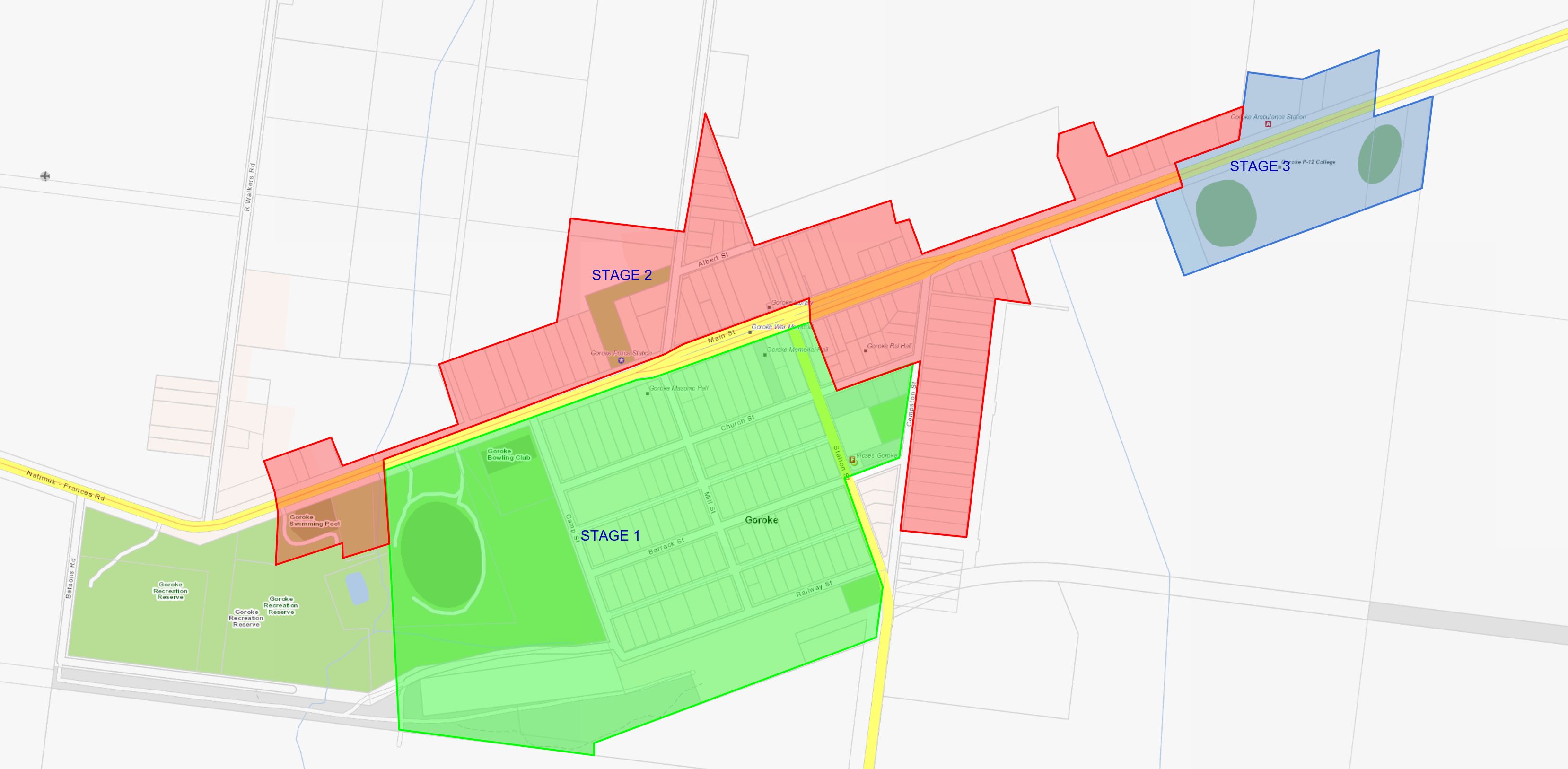
GWMWater, working with the West Wimmera Shire Council, is investing in Goroke to provide a sewerage system. The Goroke Sewerage Scheme will provide residents with a reliable, and effective wastewater collection and treatment system. The sewerage scheme will use current septic tanks on properties and deliver a reliable and effective wastewater collection and treatment system which will contribute to the prosperity and future growth of the town.
For information about the relevant charges that will apply, as well as concessions or subsidies available see our Goroke Sewerage Scheme charges and subsidies overview. If you need more information, or need support to apply for subsidies, please call our Customer Service Team during business hours on 1300 659 961.
Stage 1 - completed
Construction of Stage 1 of the Goroke Sewerage Scheme was completed in October 2021. In March 2022 the Goroke Wastewater Treatment Plant was completed. Customers within Stage 1 can arrange connection to the new sewerage system and should seek quotes from a licenced plumber before applying to connect.
Information about how to connect is available in this Fact sheet - How to Connect - Goroke Sewerage Scheme.
Stage 2 - completed
Customers within Stage 2 of the Goroke Sewerage Scheme can now connect their properties to the sewerage system. Wastewater charges will apply from 1 April 2025.
Information packs have been issued to Stage 2 customers with details on how to connect to the town's sewerage system.
Stage 2 of the Goroke Sewerage Scheme was completed in June 2024 ahead of the practical completion date of September 2024.
Goroke Sewerage Scheme - Stages 1, 2 and 3 Map
![]() Checklist for customers - connecting to the Goroke Sewerage Scheme
Checklist for customers - connecting to the Goroke Sewerage Scheme
![]() Media Release: Goroke Sewerage Works - Stage 2 completed - August 2024
Media Release: Goroke Sewerage Works - Stage 2 completed - August 2024
![]() Media Release - Goroke Sewerage Works - Stage 2 progresses - March 2024
Media Release - Goroke Sewerage Works - Stage 2 progresses - March 2024
![]() Media Release - Goroke Sewerage Scheme Works Progress - December 2023
Media Release - Goroke Sewerage Scheme Works Progress - December 2023
![]() Media Release - GWMWater to improve the environmental health of Goroke - April 2019
Media Release - GWMWater to improve the environmental health of Goroke - April 2019
![]() Terms of Reference - Goroke Sewerage Scheme
Terms of Reference - Goroke Sewerage Scheme